 |
 |
|
|
path: Home / #38 "Somebody's Going to Emergency, Somebody's Going to Jail" /The Peters Projection Map
Bob Abramms with www.odt.org in Amherst, MA wrote us the following to advise us that the NCC information below is outdated:
"They were fired as the publisher of the Peters Map in December of 2001.
"ODT was the firm that granted WEST WING permission to use the Peters Map images. NCC continued to sell the maps, sourcing them from us to serve their dwindling customer base.
"Eventually, NCC (actually their publishing arm, Friendship Press) went insolvent. We have been asked to liquidate their map inventory. West Wing viewers can obtain the map for 50-75% off retail by going to www.odt.org, then clicking on our web store, and going to the Special Deals! Close-outs. Seconds. section.
"There is also an 'official' Peters Map web site at www.petersmap.com
"Lastly, there is a detailed 4-page explanation of the Peters Map. Please feel free to link your web site to our "Explanation of the Peters Projection Map" at www.diversophy.com/petersmap.htm
"www.diversophy.com/maps.htm has a free download Chapter One of the groundbreaking book "SEEING THROUGH MAPS: THE POWER OF IMAGES TO SHAPE OUR WORLD VIEW" by Ward L. Kaiser and Denis Wood. The book reveals the biases inherent in all map projections along with tips for map users to overcome being misled by various maps.
"LASTLY, for map aficionados, as well as newcomers to cartography... Many Ways To See The World is a new video that presents twelve compelling world maps in a fast-paced program that changes the way its audience's view the world. It will be premiered at the Coolidge Corner Cinema in Brookline, MA, at 11:00AM on October 18th. The event is free and open to the public. All attendees will be given a free world map. The 30-minute video uses maps, images and stories�including how young Stuart McArthur developed McArthur's Universal Corrective Map with its unique downunder viewpoint. . You will learn how Gerardus Mercator never intended to draw the world as many of us have always seen it! Images created by Len Guelke, Arthur Robinson, Tom Van Sant, Arno Peters, Buckminster Fuller, Paul Hoffman (founder of EarthSeals) are featured players in this unique film. Full details are at www.odt.org (go to the Press Room). The video retails for $19.95 plus $5.50 shipping. That price includes copyright permission to make copies for all your friends!"
- Original information:
- Andrew M. Lindner writes us about the Peters Projection Map:
- "This week on the television series 'West Wing,' part of the plot is going to revolve around a socially conscious group that is seeking to lobby the President about having the Peters Projection Map be used in all school textbooks -- it is more accurate representation than the standard Mercator projection.
"The National Council of Churches (NCC)/Friendship Press owns the American rights to this map. I suspect that after Wednesday's show, some viewers may be searching for this map on the web.
- See:
- THE PETERS PROJECTION AN AREA ACCURATE MAP
- And then we were also sent the following link for general information on maps including the Peters Projection Map:
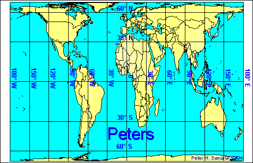
- Map Projection by Peter H. Dana, The Geographer's Craft Project, Department of Geography, The University of Colorado at Boulder (different maps are available including the following version of what was shown on the episode):
- In a news article:
- Source: The Hartford Courant
WAR OF MAPS: CONTINENTAL DIVIDE
PETERS PROJECTION REFLECTS NEW WORLD VIEW, A CONTRAST TO CLASSROOM-STAPLE MERCATOR
GREG MORAGO
07/05/2001There are certain truths learned as school children that were considered inviolate. What goes up must come down. Columbus discovered America. There are nine planets circling the sun. A fetal pig's internal organs are just like a human's. Electrons fly in rings around an atom's nucleus.
As adults, we learned not everything was that simple. Or what it seemed.
But one classroom truth was considered sacred: the map of the world. That shiny document that hung above the blackboard, and was pulled down (obscuring the penmanship strip of cursive letters) for every geography and history lesson, was a holy object. The shape of its continents, the vastness of its seas, its polar desolation -- all as accurate and provable as science allows. As fixed and permanent as Earth itself.Hah!
That map, known as the Mercator Projection Map, has been a classroom staple since there have been classrooms. And now, thanks to a bit of humor from a popular TV show, the shape of the continents as we have come to know them has been haughtily challenged. For some, a new map of the world is as shocking as, heck, the idea of Ben Franklin's being struck by lightning while flying a kite. More, actually.
The new map we're talking about is called the Peters Projection Map. It's actually not new at all. Developed by German historian Arno Peters, it was introduced in Europe in 1973; the first English- language version came out a decade later. Since its debut, the Peters Projection has been as controversial as it is odd-looking. The shapes of the continents are long and droopy, as if they'd been imprinted on Silly Putty and pulled up and down. (Arthur Robinson, considered the dean of U.S. cartographers, likened the shape of the Peters continents to wet laundry hung out to dry.) Certainly not the voluptuously curvy continents Mercator taught us.
And while the Peters Projection has been debated among cartographers for years, it probably would have remained in the academic and scientific circles had it not been for scriptwriters for NBC's "The West Wing." On the Feb. 28 episode of the popular White House drama, press secretary C.J. Craig met with a group called the Organization of Cartographers for Social Equity that argued that a new projection be the official map taught in American public schools. They pulled out the Peters Projection. C.J.'s jaw dropped. America leaned forward for a better look.
Since the episode was broadcast, the Peters Projection has been the subject of curiosity. Many who saw the episode assumed it was just another crafty bit on a particularly crafty show. Although the cartographic organization, like "The West Wing," is fiction, the Peters Projection is not. A recent rerun of the episode has only fueled the appetite for the map with the quirky-looking continents.
ODT Inc., a management consulting company in Amherst, Mass., the map's major U.S. distributor, couldn't be happier. The company's website got so many hits after "The West Wing" episode that its server melted twice in 48 hours. Before the show, ODT got maybe three to six map orders per week. In the days following the show, the company got 300. About 80 percent of the company's revenues now come from selling the weird-looking map.
"It's astonishing," said Bob Abramms, senior associate for ODT. "We're having a ball." ...
SiteMap | About Us | Home
Quotations & some other material copyrighted to John Wells Productions, et al.
Email westwing@bewarne.com to report mistakes, make comments, ask questions
(note: above email address doesn't reach anyone connected to the show itself).